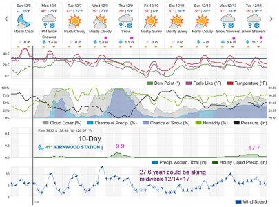
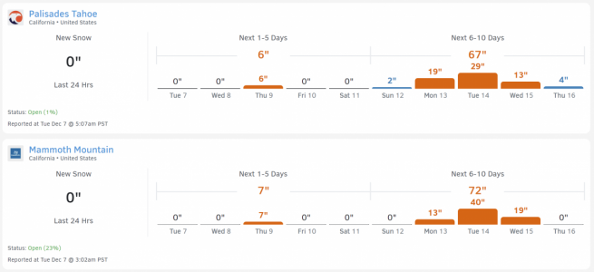
No, but now that you say it, I should have!Did you look at the webcam? snow as much as anything.
-
For more information on how to avoid pop-up ads and still support SkiTalk click HERE.
You are using an out of date browser. It may not display this or other websites correctly.
You should upgrade or use an alternative browser.
You should upgrade or use an alternative browser.
California/Nevada 2021-2022 Tahoe Ski Resorts/Conditions/Meetups
- Thread starter Andy Mink
- Start date
- Status
- Not open for further replies.
From this morning's Chronicle:
 www.sfchronicle.com
Tahoe’s winters have become somewhat erratic in the past decade, a development widely attributed to climate change. Historically low snow years in 2014 and 2015 were followed by a banner winter in 2016-2017 when several resorts recorded more than 700 inches of snowfall — well above regional averages that range between 200 and 400 inches per year.
Dry beginnings aren’t correlated with a winter’s overall snowfall. Fewer than 6 inches of precipitation fell across Tahoe in each of the past two Novembers, but both seasons saw storm cycles hit later.

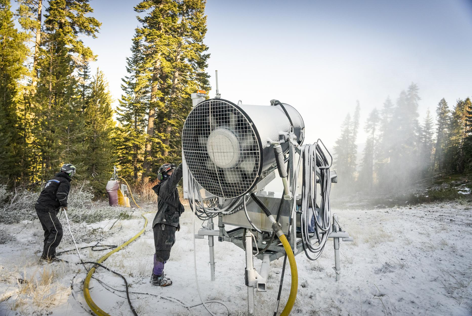
Snowless month, heat wave leave Tahoe ski runs bare after promising start
After a month of paltry Sierra snowfall, the mountains around Tahoe are dirt-dry and the...
Friday afternoon 12/3 yawn yawn...
Just looked at some weather sites including upper atmosphere jetstream models and it now looks like ten days from now for what they are worth is when Tahoe might get some kind of real storm that would set us up for mid-month pre-Christmas skiing. Notice BA at Open Snow raising his flag about then too. In any case will believe it when I see it. Until then just much zonal flow across the Northern Pacific that is capping chilly marine fog and stale tule fog below at lower elevations .
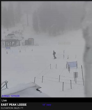
Oh well, tomorrow will make some turkey sandwiches in the morning then drive up the 55 miles to San Francisco and free park at Marina Green for some urban street exercise. For some positive vibe, here's a stormy photo from about that time last year December 14, 2020 at the base of East Peak Lodge at Heavenly as a storm that deposited 14" was waning.

Last edited:
Resort specific forecast for PT-
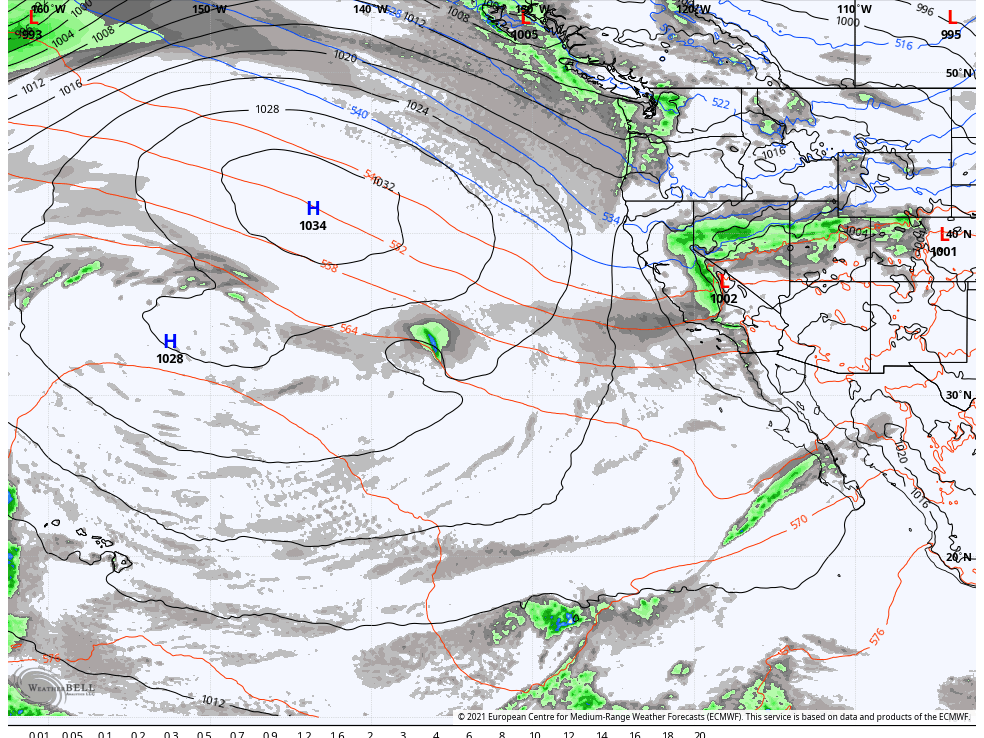
 opensnow.com

Colder Temps & Some Snow This Week... | Palisades Tahoe Daily Snow Forecast | OpenSnow
A few rain & snow showers are possible Monday afternoon/evening with high snow levels. Colder Monday night through Tuesday...
I saw BA from OpenSnow and Boreal on the Today Show this morning when they were discussing the lack of snow so far this season in the West.
Yeah, the snow-water equivalent readings are down a lot across the whole of the western US. Usually you'll see things more regionally, where maybe Colorado is red, but Tahoe's OK and showing green or blue, or maybe Tahoe's bad, but the Pacific NW or Montana/Idaho are good. This is pretty universally low though...I saw BA from OpenSnow and Boreal on the Today Show this morning when they were discussing the lack of snow so far this season in the West.
What I don't know is what the time frame is the measurements... i.e. if it says 35% in the graphic below, is that for the year? The past week? Just the winter season? Does anyone know? I'd like to know, like with snow stakes, that it was reset on X date or time. I can't seem to find that on the NRCS site.
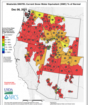
Not sure I'm getting your question;What I don't know is what the time frame is the measurements... i.e. if it says 35% in the graphic below, is that for the year? The past week? Just the winter season? Does anyone know? I'd like to know, like with snow stakes, that it was reset on X date or time. I can't seem to find that on the NRCS site.
but it has it in the title and side legends as "SWE % of normal" for the water year. Water year is typically July1-Jun30 (so plenty of time in summer to start from 0). It is percentage against the normal snowpack for the day in the season.
I believe they take those 30year median for the site; smooth that curve; then it is is just do straight % against that median snowpack for the day. Each area in the graphic is the average of the selected sensors for that area.
Snotel sensors take hourly measurements; but the graphic looks like a daily generation. It doesn't need to reset like resort stakes; because it's purpose is for water planning and measuring water equivalent (by sensing the total weight). It's not specifically for skiing. So the actual depth of the snow is not important; just the weight.
Last edited:
I think water year runs 10/1-9/30, although 9/1-8/31 seems like it would work better since there is more rain/snow in West at beginning of Oct than Sept. 10/1-9/30 is also the rainfall year our local paper uses.
Following from https://www.nrcs.usda.gov/wps/portal/wcc/home/snowClimateMonitoring/30YearNormals also looks like it starts 10/1.
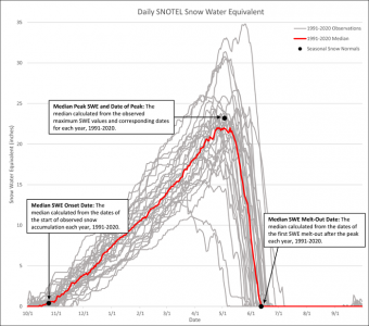
Following from https://www.nrcs.usda.gov/wps/portal/wcc/home/snowClimateMonitoring/30YearNormals also looks like it starts 10/1.

Last edited:
for the water year. Water year is typically July1-Jun30 (so plenty of time in summer to start from 0)
I think water year runs 10/1-9/30
Yes, that's what I'm looking for. Sorry to not explain better. So the SWE measurements reset on either July 1 or Oct 1... I'd like to know which is really is.
I.e., I know that a 35% in the graphic means 35% of normal, but measured since when? Is that 35% of the normal from July 1st through today? Or 35% of normal from October 1st through today?
The reason I want to know is to understand how to interpret the numbers. If the starting date is July 1, and it was a very dry summer, we could be having a normal winter (precip-wise, if not temp-wise) but still show a lot of red and orange and take a long time to catch up to normal. (The reverse could happen too.) If the starting date is Oct 1, then this more accurately represents how the "winter" is going for precipitation.
tony is right, I am wrong,. It is oct1.
The snowtel is for SNOWPACK. So all that july/aug/september precip should be Rain or quickly melts and just runs off and still is a 0 reading of Snowpack.
Is the confusion is what the % is comparing against? Keep in mind it is a % comparison against the historical Curve of snowpack for that day; it's not trying to match against a straight-line Total Precip, or the peak snowpack.
You are right to point out early season, when normal is like 2inch, and you get 8inches, the snowtel is going to say stuff like 400% of normal. But it's really an absolute of just 6inches.
so it's easier to catch up % wise in early season when the "normal" target is very low versus peak season.
The amount of actual snow for each % of "normal" changes as the season progresses.
Last edited:
Headlines written by editors does not make the science behind the story fake news. https://www.latimes.com/california/...w-california-could-come-sooner-than-you-think ends with "Unfortunately, he said, “the freezing point of water is non-negotiable.”"The headline overstates the information source probably because the above better serves as click bait. Also urban newspaper reporters do not tend to be mountain people so tend to understand weather and mountain subjects like this poorly.
Generally atmospheric temperatures change 3F (1.8C) degrees per 1000 feet. Current predictions for 2050 show a change of just 1.6C higher. But lets go way higher. A change of 4C at the Tahoe latitude would mean a change of average storm snow levels from about 6,000 feet to 8200 feet. That would of course greatly affect Tahoe ski resorts making conditions at the base of Kirkwood similar to those now at the base of Squaw. The Northern Sierra would see mostly rain storms in winter while there would still be considerable snow over much of the Southern Sierra because those mountains have vastly much more square miles of higher elevations above 8,000 feet. Thus the headline more properly should be:
Snowpack at Tahoe could disappear in just 25 years
California Physical Map and California Topographic Map
A colorful physical map of California and a generalized topographic map of California - by Geology.comgeology.com
Note Lake Tahoe is at, 6,250 feet above sea level while the High Sierra has many peaks over 13k and 14k. Also the reporter makes it sound like we would be losing water. That may be true if the northern jetstream changes to the north putting California in desert latitudes but if snow just became rain, it would not make much difference with what flows into reservoirs. Each winter most of the Sierra north of Tahoe is already in the rain zone and reservoirs like Shasta or Oroville have no problem filling up. It just won't happen during summer.
While @SSSdave's post says "That would of course greatly affect Tahoe ski resorts making conditions at the base of Kirkwood similar to those now at the base of Squaw", I think most Tahoe skiers would see that as a terrible thing as we don't want to be mostly limited to skiing Kirkwood, Mt. Rose and the top of Squaw and Heavenly or mad-made. You think weekends and holidays are going to be crowded this year when ski areas can finally open and stay open? This would be much worse.
@SSSdave also says "if snow just became rain, it would not make much difference with what flows into reservoirs." While that may be true, it is not that simple since the snowpack acts as a reservoir and (quoting from latimes) "the steady, slow melting of snow each spring and summer has long acted like a time-release that provides more water at a moment when precipitation tends to stop and demand begins to surge". If all or most of the precipitation in the Northern and Central Sierra falls as rain the big reservoirs like Oroville (which nearly failed during atmospherics river event in Feb 2017 which led to the evacuation of 188,000 people and cost $1.1B to repair - see https://en.wikipedia.org/wiki/Oroville_Dam_crisis) and Folsom could be overwhelmed in big storms and have to release water which could lead to downstream flooding they were built to prevent. While the water still "flows into reservoirs", it may not be able to be stored until needed into Summer, Fall and future dry years. In Spring 2021 the little expected snowmelt mostly did not make it into reservoirs as it was absorbed by dry ground or evaporated/sublimated before getting there.
And while @SSSdave says "High Sierra has many peaks over 13k and 14k" (that would still get snow), there are no CA ski areas above 11K and most of the peaks over 13K and 14K are far from roads or electricity and are in National Parks or Wilderness area that would prevent development of ski areas.
Googling "does california rainfall year begin in july or october" found https://www.abc10.com/article/weather/california-rain-record-period/ among other sources. some behind paywall. Video at link above explains it well and story includes "Until recently, the record period was July to the end of the following June, but officials with the National Weather Service moved the period of record to October to September to better reflect many water resource agencies time period. Using an alternate set of dates helps avoid misunderstanding a rainy season as being really wet or really dry." In a high snowfall year, there can still be snowmelt runoff past July 1.Yes, that's what I'm looking for. Sorry to not explain better. So the SWE measurements reset on either July 1 or Oct 1... I'd like to know which is really is.
I.e., I know that a 35% in the graphic means 35% of normal, but measured since when? Is that 35% of the normal from July 1st through today? Or 35% of normal from October 1st through today?
The reason I want to know is to understand how to interpret the numbers. If the starting date is July 1, and it was a very dry summer, we could be having a normal winter (precip-wise, if not temp-wise) but still show a lot of red and orange and take a long time to catch up to normal. (The reverse could happen too.) If the starting date is Oct 1, then this more accurately represents how the "winter" is going for precipitation.
In other 'news', local TV weather person showed map predicting 74" of snow early next week (Sun into Mon) at Kingvale and Kirkwood. BA as of yesterday is not as sure and says "A stronger storm is forecast to spin up in the trough off the CA by next Monday. Ahead of the storm, we may see southerly flow which will limit moisture from pushing east into the Sierra" and "At some point Tuesday - Wednesday the storm should shift inland with rain and snow pushing into the Sierra. We will continue to watch the trends as we get closer." At least there is a pattern change.
Last edited:
Andy Mink
Everyone loves spring skiing but not in January
Moderator
SkiTalk Tester
SkiTalk Supporter
I'm hesitant to put the mower away and get the snow blower out. I'd hate to screw up this system! Maybe I'll wash my truck today. That should help.
Ah... I didn't realize it let liquid drain in order to measure just snowpack. I thought the SWE measurement meant all precip was collected for the total water equivalent, whether it was snow or not. (Since they basically weigh the snowpack, having liquid in there would also get weighed, and should be correct regardless, however they do it.)The snowtel is for SNOWPACK. So all that july/aug/september precip should be Rain or quickly melts and just runs off and still is a 0 reading of Snowpack.
So that really helps interpret the graphic I showed above, and removes the need to know when it "reset". (As summer naturally resets it, and you start from zero.) If it's just measuring the snowpack at a point in time, and comparing to the same measurement across past years on the same day, that simplifies things.
Basically it's saying that the current snowpack on date X, weighs some percentage of the average snowpack on date X over the last number of years.
Last edited:
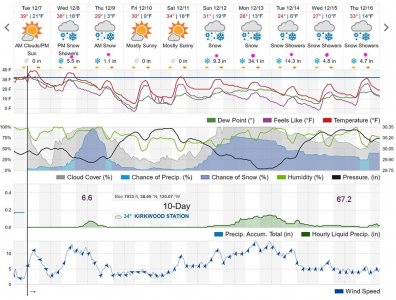
Notice how snowfall forecasts have risen greatly in just 2 days from my previous post. Usual delay of models with large storms. Expected was likely because there is an ongoing Kona low causing flooding in Hawaii that is putting a lot of moisture into the atmosphere that could be fetched northward, very cold stale Alaska latitude temperatures to be drawn into the Gulf of Alaska low, and the jet stream models looked certain days ago for something big. Note how cold temperatures show below freezing at 8k during this period. For Tahoe lake level subtract 5 degrees. Check with BA at OpenSnow for better details.
May not be skiing next midweek because if it does snow that much Monday, highways will close for a couple days and ski resorts all still closed, will take a few days to ramp up. But that is a great thing season wise as it could guaranty good skiing through January even with another dry period. Sun has such a low altitude mid winter and skies are often so cloudy that snow tends to not degenerate much so am hopefully looking forward to weeks of mid winter packed powder conditions.
Ah... I didn't realize it let liquid drain in order to measure just snowpack. I thought the SWE measurement meant all precip was collected for the total water equivalent, whether it was snow or not. (Since they basically weigh the snowpack, having liquid in there would also get weighed, and should be correct regardless, however they do it.)
So that really helps interpret the graphic I showed above, and removes the need to know when it "reset". (As summer naturally resets it, and you start from zero.) If it's just measuring the snowpack at a point in time, and comparing to the same measurement across past years on the same day, that simplifies things.
Basically it's saying that the current snowpack on date X, weighs some percentage of the average snowpack on date X over the last number of years.
The sensor itself is just a pad out there that has a pressure sensor (like a bathroom scale) if i understand correctly. So what runs off, runs off. what stays slushy, stays slushy.
Yea there are different charts for Total Precip which was what you were thinking of.
So you are right CA is still way above normal for precip due to the big Oct ARs but it has all melted out, so back to way behind for snowpack.
Last edited:
Email update from Sierra-at-Tahoe:
"I just wanted to give you a quick update on Sierra at Tahoe. Things are moving along up here and more work is continuing to get done every day. The biggest recent news is that the haul rope for the Grandview Chairlift has been completed in Switzerland and should be landing on the east coast any day now! There is still a lot of work to be done before we can think about an opening date, but I just wanted everyone to know things are moving along."
"I just wanted to give you a quick update on Sierra at Tahoe. Things are moving along up here and more work is continuing to get done every day. The biggest recent news is that the haul rope for the Grandview Chairlift has been completed in Switzerland and should be landing on the east coast any day now! There is still a lot of work to be done before we can think about an opening date, but I just wanted everyone to know things are moving along."
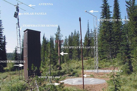
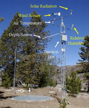
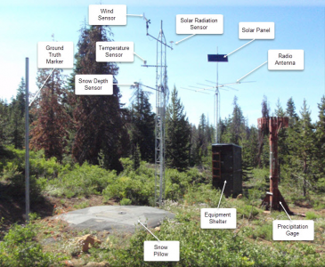
Well, according to some things I've read, it's actually a big flat bladder filled with antifreeze and an outlet, and just measures how much of the liquid is squeezed out of the bladder by the weight of the snowpack.The sensor itself is just a pad out there that has a pressure sensor (like a bathroom scale) if i understand correctly.
I was also envisioning something surrounding the bladder to mitigate wind effects - a big open tube or column. But I suppose that's not strictly necessary and once it gets covered up a bit wouldn't be needed at all - you'd just have the weight of whatever the snowpack actually is sitting on it. That appears to be the case in these photos... the "bladder" is the big ground level pad, which is used for SWE. The snow depth sensor is a sounder that measures snow depth with a laser/radar/infrared (not sure what kind of "beam" it uses).
- Status
- Not open for further replies.
Sponsor
Members online
- Wade
- benx2023
- Norther1
- bckevin91
- Tom K.
- PaganSkier
- Mike King
- Jersey Skier
- trailtrimmer
- jetwolverine
- Andy Mink
- chris_the_wrench
- Philpug
- pchewn
- ajcolorado
- tromano
- dusty
- Jms990
- dwoovre
- Scruffy
- bennettc14
- Cameron
- rip
- Posaune
- Noodler
- smv
- JohnL
- Doug Briggs
- MissySki
- FlyNavy
- fileguide
- Matt Merritt
- salvatore
- zircon
- AngryAnalyst
- Neurodrive
- freeskier1961
- RTsucks
- blackke17
- Erik Timmerman
- Mendieta
- LiquidFeet
- jdwalk
- teejaywhy
- BLiP
- Dwight
- srubi
- Wasatchman
- mdf
- deadheadskier
Total: 3,708 (members: 152, guests: 2,515,robots: 1,041)


