Yes, high-clearance 4WD vehicles, motorcycles (off-road capable), and mountain bikes are the recommended means of travel but I've seen conventional passenger vehicles have a go. At the bottom, the road forks with one way leading to Moab following a circuitous route along the shore of the Colorado River (and leaving the Park) and the other circumnavigating a significant amount of the Island in the Sky (and remaining in the Park) on the White Rim Trail ((high-clearance 4WD vehicles, motorcycles (off-road capable), and mountain bikes only)). A similar road (the Horsethief Trail) to the Shafer Trail descends from the Island on the opposite side and completes the loop for those interested in driving or riding the 100-plus-mile route. The scenery is absolutely stellar along the full length of the White Rim Trail.Do people take vehicles on that?
-
For more information on how to avoid pop-up ads and still support SkiTalk click HERE.
You are using an out of date browser. It may not display this or other websites correctly.
You should upgrade or use an alternative browser.
You should upgrade or use an alternative browser.
Photo(s) of the day...
- Thread starter Mike King
- Start date
Yes. It's a numbered road. The road connects the park with Moab via Potash.
My first time to the White Rim, we took the road outlined below as we had some time to spare. When I reached the junction of the White Rim Road and looked up to the canyon wall I thought 'Shit! The map is wrong. It's a dead end.' But no, you go up a nearly vertical wall and emerge near the visitor center.

 www.google.com
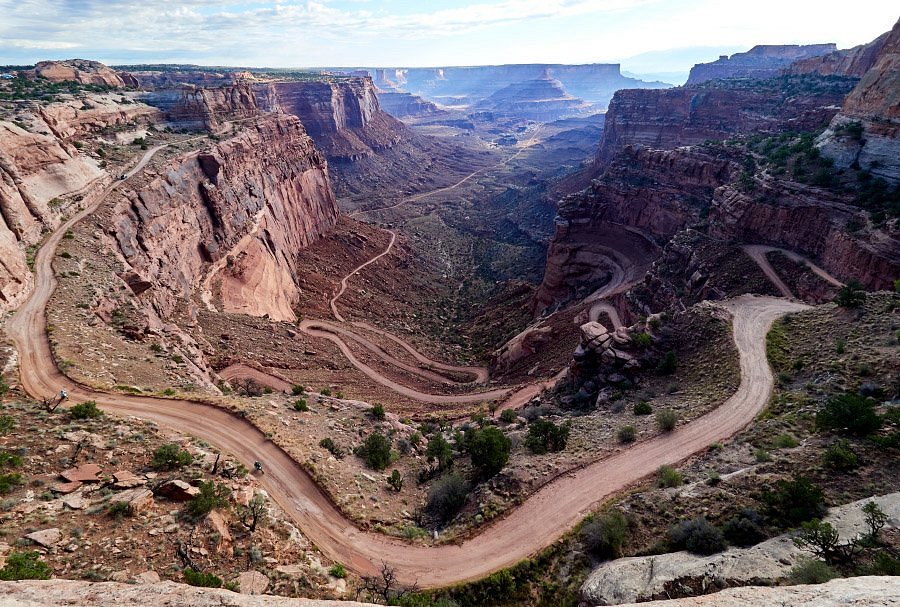
You can drive around Canyonlands on the White Rim. Most people that do the WR on bikes have sag vehicles that lead/follow them around. These pictures are a conglomeration from a few trips.

Looking down onto the Shafer road. There is no room for mistakes or nature forbid, a flat at speed.

Unexpected flora.
 One of our camp sites.

Charcoal fire for the paella.

Every trip we had paella as one of the organizers was a chef as well as a rider.

My Taco on a climb. This was steep, but not tricky. Note the road in the distance from whence we came. Most of the challenges of driving were keeping your eyes on the road. Many places the road was the edge of a sheer drop. Others you had to deal with hairpins or sand. Another challenge was keeping ATF in the transmission.

One of the sag wagons managed to totally empty the transmission of fluid. The owner said 'You don't need 4WL, just 4WH will be enough.' Unfortunately that meant the tranny was working overtime to make the steep hills and it overheated forcing the fluid out the filler, apparently and stranding us for a day at site halfway around the loop trail.
I ventured out with my Taco to Moab with a riding partner to fetch a case of ATF. We left near first light and arrived back in the dark. I needed to use all my spare fuel to make it out. I seriously overestimated the mileage I'd get.
After refilling the AT with ATF, the truck made it out of the park. The owner designed the diaper (above) to catch any ATF that might find its way out as the park service was upset that we'd 'dumped' a transmission full of fluid already. As it turned out, the tranny didn't lose another drop; the diaper was clean when we got back. Unfortunately, the truck needed to be towed somewhere between Moab and CO as the transmission finally gave up the ghost.

This is the road out at the west side of Canyonlands. It isn't nearly as imposing as Shafer, but it did get washed out at one point and closed the WR for a while.

This is one of the concrete repairs that they put in where erosion was obviously going to continue.

In SW style, junked cars dispatched off the side of the road.
Edit: @Daniel is right on all accounts. It is a beautiful journey around the White Rim no matter how you do it. Some ride it in one day (insane). One time we planned for a day off and brought floating toys to enjoy ourselves in a not usual way on the ride.

My first time to the White Rim, we took the road outlined below as we had some time to spare. When I reached the junction of the White Rim Road and looked up to the canyon wall I thought 'Shit! The map is wrong. It's a dead end.' But no, you go up a nearly vertical wall and emerge near the visitor center.
Island in the Sky Visitor Center to Moab
www.google.com
You can drive around Canyonlands on the White Rim. Most people that do the WR on bikes have sag vehicles that lead/follow them around. These pictures are a conglomeration from a few trips.
Looking down onto the Shafer road. There is no room for mistakes or nature forbid, a flat at speed.
Unexpected flora.
Charcoal fire for the paella.
Every trip we had paella as one of the organizers was a chef as well as a rider.
My Taco on a climb. This was steep, but not tricky. Note the road in the distance from whence we came. Most of the challenges of driving were keeping your eyes on the road. Many places the road was the edge of a sheer drop. Others you had to deal with hairpins or sand. Another challenge was keeping ATF in the transmission.
One of the sag wagons managed to totally empty the transmission of fluid. The owner said 'You don't need 4WL, just 4WH will be enough.' Unfortunately that meant the tranny was working overtime to make the steep hills and it overheated forcing the fluid out the filler, apparently and stranding us for a day at site halfway around the loop trail.
I ventured out with my Taco to Moab with a riding partner to fetch a case of ATF. We left near first light and arrived back in the dark. I needed to use all my spare fuel to make it out. I seriously overestimated the mileage I'd get.
After refilling the AT with ATF, the truck made it out of the park. The owner designed the diaper (above) to catch any ATF that might find its way out as the park service was upset that we'd 'dumped' a transmission full of fluid already. As it turned out, the tranny didn't lose another drop; the diaper was clean when we got back. Unfortunately, the truck needed to be towed somewhere between Moab and CO as the transmission finally gave up the ghost.
This is the road out at the west side of Canyonlands. It isn't nearly as imposing as Shafer, but it did get washed out at one point and closed the WR for a while.
This is one of the concrete repairs that they put in where erosion was obviously going to continue.
In SW style, junked cars dispatched off the side of the road.
Edit: @Daniel is right on all accounts. It is a beautiful journey around the White Rim no matter how you do it. Some ride it in one day (insane). One time we planned for a day off and brought floating toys to enjoy ourselves in a not usual way on the ride.
Last edited:
This is looking at Shafer from the floor of the canyon. You can't see the road up as you approach.


View from White Crack. The vistas go on forever.


Here's a video of sag vehicles climbing one of the steeper and longer pitches. Nothing inherently dangerous, but if you don't like being near a drop in a vehicle, it is unsettling.
View from White Crack. The vistas go on forever.
Here's a video of sag vehicles climbing one of the steeper and longer pitches. Nothing inherently dangerous, but if you don't like being near a drop in a vehicle, it is unsettling.
Last edited:
Thanks for the great photos!
Do tell, Doug, what was the make and model of the vehicle with the transmission trouble? Not a Toyota, I'm hoping!

 www.tripadvisor.com
I wonder how many relationships ended on that trail?
www.tripadvisor.com
I wonder how many relationships ended on that trail?
I've mountain biked it a couple of times, but the idea of driving it terrifies me. On my bike, I'm hugging the inside edge of the inside track and it still feels way too close to the edge in the narrow spots. Freaks me out. It's a long way down!Nothing inherently dangerous, but if you don't like being near a drop in a vehicle, it is unsettling.
Do tell, Doug, what was the make and model of the vehicle with the transmission trouble? Not a Toyota, I'm hoping!
For good entertainment and a reminder why you should never buy a used rental car, I've always loved the Tripadvisder reviews of the Shafer Trail.Do people take vehicles on that?
Shafer Trail - All You Need to Know BEFORE You Go (with Photos)
www.tripadvisor.com
It was a Ford, but the make had nothing to do with it. The owner's instructions were flawed and apparently it didn't have an AT idiot light. My Tacoma does.what was the make and model of the vehicle with the transmission trouble?
...
I wonder how many relationships ended on that trail?
I watched one relationship nearly collapse on the trail, but they are going strong now. I narrowly avoided a train wreck of my own, but only realized it 10 years later. :-|
Excellent photos and recounting of your experiences on the White Rim Trail Doug! You and your travel companions must have been planners and secured a permit soon after they became available from the Park Service each time you undertook an adventure there. I know it used to be quite competitive to obtain one and surely it's even more challenging now. I've done it the, as you put it, "insane" way a couple of times. A couple of Snowbird skier friends invited me to join them on short notice the first time. We rode the entire loop in a clockwise direction on ~ June 1, 1989 (I believe). Our saving grace was a spell of cold weather that had brought snow down to the east bench of the Salt Lake Valley the morning of the day we left for Canyonlands. We camped at the old primitive campground on the Island (cold night) and headed down the Shafer Trail before sunrise. We were carrying plenty of water and, while taking a rest at the junction of the White Crack spur trail, a backcountry ranger in a jeep rolled up and replenished our water supply, allowing us to not have to strictly regulate our liquid intake going forward. We made it back to the old Island visitor center at least an hour before sunset. The second time I rode it solo in the opposite direction from the intersection of the unsealed road that leads to the Horsethief Trail descent and the paved road leading into the Park. That occurred in October of 1997 and went according to plan. I'd upgraded my mountain bike by that time, the weather was perfect, and I'd done numerous high-elevation all day exploratory rides on Boulder Mountain, Thousand Lake Mountain, Fish Lake Mountain, the Henry Mountains, and the Wasatch Plateau the preceding summer and early autumn, many of them solo. Started in the dark with a headlamp and finished just before sunset. I have an acquaintance who rode it solo overnight during a late September full moon a couple years ago or so and I'm tempted to replicate that adventure before I get any older. Spreading the ride out over several days, camping at the primitive campsites, and using a sag wagon sounds like luxury!
Your travel companion with the Ford vehicle owed you a huge debt of gratitude. Letting the Park Service handle the matter would have been exponentially more expensive I suspect. I knew of a person whose vehicle broke down in the Maze District of Canyonlands N.P. a number of years ago and it cost him a fortune to have it extracted. Cool idea to take the floatation toys for use on the river. That would have been one way to set foot in the very-seldom-visited Maze District, assuming the current was cooperative and the floatation toy occupant was a strong swimmer if they were unexpectedly carried downstream. I believe those old wrecked vehicles in your photo can be seen from the switchbacks on the Horsethief Trail ascent/descent. The photo of your Taco and the embedded Youtube video both appear to be ascents of Murphy Hogback, the toughest climb on the White Rim not named Shafer or Horsethief.
Since this is the Photo of the Day forum, here's a couple from two different Utah National Parks:
Chimney Rock - Capitol Reef N.P. with the northeast slope of Boulder Mountain in the background.

A display of hoodoos in Bryce Canyon - Bryce Canyon N.P. with the southwest slope of Boulder Mountain in the background.

Your travel companion with the Ford vehicle owed you a huge debt of gratitude. Letting the Park Service handle the matter would have been exponentially more expensive I suspect. I knew of a person whose vehicle broke down in the Maze District of Canyonlands N.P. a number of years ago and it cost him a fortune to have it extracted. Cool idea to take the floatation toys for use on the river. That would have been one way to set foot in the very-seldom-visited Maze District, assuming the current was cooperative and the floatation toy occupant was a strong swimmer if they were unexpectedly carried downstream. I believe those old wrecked vehicles in your photo can be seen from the switchbacks on the Horsethief Trail ascent/descent. The photo of your Taco and the embedded Youtube video both appear to be ascents of Murphy Hogback, the toughest climb on the White Rim not named Shafer or Horsethief.
Since this is the Photo of the Day forum, here's a couple from two different Utah National Parks:
Chimney Rock - Capitol Reef N.P. with the northeast slope of Boulder Mountain in the background.
A display of hoodoos in Bryce Canyon - Bryce Canyon N.P. with the southwest slope of Boulder Mountain in the background.
I'm currently viewing a woman's profile on a dating site:
Blonde 33 From London Great Personality 5ft 3 green eyes.
Don't get me wrong, I like short girls, but 3 green eyes?
No wonder she can't find a bloke.
Blonde 33 From London Great Personality 5ft 3 green eyes.
Don't get me wrong, I like short girls, but 3 green eyes?
No wonder she can't find a bloke.
DOH !!!!I'm currently viewing a woman's profile on a dating site:
Blonde 33 From London Great Personality 5ft 3 green eyes.
Don't get me wrong, I like short girls, but 3 green eyes?
No wonder she can't find a bloke.
Wrong page!!!
I saw that this morning but I didn't want to say anything.DOH !!!!
Wrong page!!!
Had an amazing drive today from Aspen over Indy Pass and down AR river basin with a side trip to Capulin Volcano Nat'l Monument and on to west Texas. No time to sort photos but I'll have some later for this thread. 
Maybe I'll do a trip report, continuing eastward tomorrow.
Maybe I'll do a trip report, continuing eastward tomorrow.
Brown Dog coffee in Buena Vista. We make that AR River canyon drive a lot between CO and NM. So beautiful.
Friday returned from 6 days up at Redwood National Park, a 400 mile drive from where I live in the SF Bay Area. Ton of post processing to do next couple weeks. On the return along California Highway 1, took the above shot from a familiar flowery coastal bluff. Our cool moist coastal bluffs are always the last flowering lower elevation areas and species tend to have low height due to the frequent northwesterly winds. A6000 and 60mm lens 2 frame stitch and focus stack blended from 14 shots, 6500 by 6000 pixels.
Downsized for web while the two below images are crops that show the actual 100% pixels detail.
[mouse select to enlarge)
This is an actual numbered public road going to the off-grid community of Deer Park in southern British Columbia.Do people take vehicles on that?
This is a numbered provincial highway (BC Hwy 31) near Trout Lake, British Columbia. The community of Trout Lake has all of them there modern amenities, like power and running water.
Last edited:
Many full-sized pick-up trucks (including the one I currently own) have a factory transmission temperature gauge. They are often also equipped with substantial supplemental cooling, which should be considered a necessity in the American southwest.It was a Ford, but the make had nothing to do with it. The owner's instructions were flawed and apparently it didn't have an AT idiot light. My Tacoma does.
And a very cool old restored hotel.The community of Trout Lake has all of them there modern amenities, like power and running water.
Sunset at Seaside OR beach.

I hiked Magic Mountain in Vermont the other day. Mainly stuck to the service road:


Sponsor
Staff online
-
 TriciaThe Velvet Hammer
 -
 Jim KenneyTravel Correspondent
 -
 PhilpugNotorious P.U.G.
Members online
- GregK
- skiki
- SKI-3PO
- oldschoolskier
- Chuck danache
- SpeedyKevin
- istin
- Mothertucker
- zircon
- bisikaufmann
- VickieH
- BullMcCabe
- crgildart
- JCF
- Tricia
- Crank
- pete
- JFB
- RTsucks
- jkmeye
- BLiP
- charlier
- Mike King
- TomPietrowski
- mike^
- river-z
- jt10000
- RiderRay
- tomahawkins
- aveski
- mcmary
- Wasatchman
- Jim Kenney
- Mendieta
- geepers
- coldski
- Nathanvg
- BlueSky
- esteban525
- Bozzenhagen
- Wilhelmson
- Philpug
- mike_m
- deadheadskier
- Spoorosew
- my07mcx2
- Dr.T
- DevinS
- LewyM
- AlexisLD
Total: 3,372 (members: 138, guests: 2,475,robots: 759)