Holds it together a bit too well in the air so it looks like its planned but the landing and the skis give it away.
Rather more soberly this:
Sept personnes ont été tuées dans des avalanches ces derniers jours en Suisse, notamment aux Rochers-de-Naye dimanche et à Siviez et Verbier (VS) lundi. Un accident de ski a également coûté la vie à un homme à Verbier.

www.rts.ch
One of the incidents-
(Google translate)
Fatal fall in Verbier (VS)
In Verbier, a skiing accident claimed the life of a Swede living in the canton of Vaud on Sunday. This 46-year-old man was riding off the groomed slopes when he "clearly fell from a rock about six meters high when visibility was restricted", explains the Valais police.
The man had set off on an ungroomed route between two tracks in the "Lac des Vaux" sector. He was found approximately 80 meters below where he left the runway. Transported on a sledge, then helicoptered by Air-Glaciers to Sion hospital, the forty-year-old succumbed to his injuries in the evening.
——————————-
I’ve skied that area but not the side he was on. You’re right near the lift terminal. Last time I was there on a powder day I resisted following tracks that head off the back. It was snowing a bit and blowing, and it looked like a bad idea. Never mind I had no idea of the intimate topography. I knew where it ended up, but it’s a long way and deadly if you don’t know it. Went around the other way. At some point you have to make this little right turn. The entry to the turn required a little side stepping in rocks. As you make the turn you look over and it’s not pretty. Some serious rocks, couloirs down there. Eventually, after four runs in that spot I’m used to it, but if you went into that turn with speed because you couldn’t ski, you’d be screwed. There are no “Falaise”, Cliff, signs there per usual.
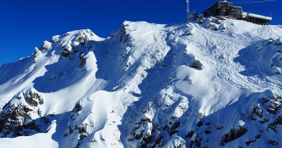
I’m pretty sure it’s the spot I marked on the photo from the article.
The thing is, you don’t see it from this angle. You see it from the other side, and everything just disappears. It’s a bad idea to go exploring with no very specific knowledge of the terrain.
The building here is the upper terminal for the lift “Funispace”, the place is Attelas
View from the other side. The yellow arrow corresponds to one of those peaks above^.
The lift parallel to the top edge is Lac des Vaux 1.
If you look above the lift bases you’ll see a traverse going off to the right. That’s a Route Itinéraire, shown in yellow, the Vallon d’Arbi that goes down to the town La Tsoumaz on the map. Those routes are semi controlled and gated. A few years ago 4 people were killed in an avalanche on that route, maybe two weeks after I was there. That time I didn’t ski it, conditions had been rain at that altitude and it had refrozen. Person I ski with went with a small group. One of them fell and slid a long way and had to go to a first aid clinic. One of their friends was killed in the slide a few weeks later.
The people killed in the current avalanche were on another Route Itinéraire, the Col des Gentianes. Where exactly, I can’t tell.
All these places are shown on the map of the ski area. Note in the description of the guy who fell off the rock, just past the lift terminal, that it was “outside the ski area”, but clearly on the map. That’s the big difference between North America and Europe.