I’m an average East Coast rider living at sea level. I ride twisty singletrack a couple times a week, complete with roots, rocks, and minimal elevation gain. I thrive on gravity fed trails and am known to enjoy the challenge of technical riding. I loathe the climb…but you gotta get up, to get down.
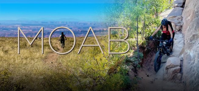
Moab’s grippy sandstone features are in complete contrast with the slick granite slabs us East Coasters are used to. Spending all day in the blazing sun confirms that sunscreen is a necessity in your pack. And the lack of roots is a welcoming characteristic of desert riding. It’s easy to see why Moab is on (nearly) every mountain biker’s bucket list.
Early in my mountain bike obsession, my husband and I visited Moab. During that trip we scheduled a date with the WE: The Whole Enchilada. Due to bad weather at higher elevations, the shuttle wasn't able to complete the journey to Geyser Pass. They dropped us off at a lower trailhead on Sand Flats Rd. We rode the last two sections: about half the enchilada. Fast forward 7 years, we decided it was time to go back and tackle the whole thing.
 If you’re not familiar with the WE, here’s the Cliff Notes version: It’s a series of 6 trails, nearly 27 miles, and 8,000 feet of descent, stretching from high in the La Sal Mountain range down to where the Colorado River meets the bottom of the Grandstaff Canyon. Despite many internet outlets calling this a “downhill run”, I’d argue otherwise. It trends mostly downhill, but it’s filled with punchy uphills, technical climbs, and one long-winded, high-altitude ascent.
All but the most intense mountain bikers ride the WE as a shuttle run. There are various bike shops in town that offer a ride for a fee. I chose the shop that was closest to our temporary residence for easy access to a 7:30AM departure. Porcupine Shuttle took us on a 50-minute van ride up Sand Flats Rd. to Geyser Pass where we were dropped off.
Burro Pass
The Burro Pass trail could easily be broken up into four sections, the warm-up, the climb, the steeps, and the flow.
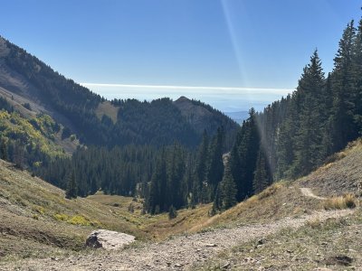
The warm-up; quite literally. After getting dropped off at a cool 35°F, using the latrine, quick mechanical checks, and allowing a few [fast looking] riders to get out in front of us, we started down the trail. The path winds through aspen filled forests, and across meadows of golden grasses with impeccable views of Mt. Mellenthin. The aspens were just starting to turn yellow, and the frost lined trail gave off a crystal-like sparkle in the sun. It wasn’t long before I was shedding layers.
 After this short warm-up we hit the largest climb on the WE, ascending 1000 feet in 1.5 miles (peak elev. 11,200 feet). Coming from a life at sea level (household elev. 40ft), I was not prepared for how difficult climbing at that altitude would be. Prior to this adventure, I was given the advice “don’t try to be a hero, just walk Burro Pass”. I’ll echo that advice to anyone that doesn’t adventure in high altitudes regularly.
At the top of the pass, I managed to catch my breath, eat some snacks, and take in the gorgeous views. I got up, now I was ready to get down. The steep descent immediately starts out on a gnarly, loose single track. It reminded me of New England riding, on forested trails that were once only used by hikers. Once through the initial gnar, Burro offered up a fun, playful, downhill ride, full of little bumps and jumps that could keep me entertained for hours.Moab’s grippy sandstone features are in complete contrast with the slick granite slabs us East Coasters are used to. Spending all day in the blazing sun confirms that sunscreen is a necessity in your pack. And the lack of roots is a welcoming characteristic of desert riding. It’s easy to see why Moab is on (nearly) every mountain biker’s bucket list.
Early in my mountain bike obsession, my husband and I visited Moab. During that trip we scheduled a date with the WE: The Whole Enchilada. Due to bad weather at higher elevations, the shuttle wasn't able to complete the journey to Geyser Pass. They dropped us off at a lower trailhead on Sand Flats Rd. We rode the last two sections: about half the enchilada. Fast forward 7 years, we decided it was time to go back and tackle the whole thing.
All but the most intense mountain bikers ride the WE as a shuttle run. There are various bike shops in town that offer a ride for a fee. I chose the shop that was closest to our temporary residence for easy access to a 7:30AM departure. Porcupine Shuttle took us on a 50-minute van ride up Sand Flats Rd. to Geyser Pass where we were dropped off.
Burro Pass
The Burro Pass trail could easily be broken up into four sections, the warm-up, the climb, the steeps, and the flow.
The warm-up; quite literally. After getting dropped off at a cool 35°F, using the latrine, quick mechanical checks, and allowing a few [fast looking] riders to get out in front of us, we started down the trail. The path winds through aspen filled forests, and across meadows of golden grasses with impeccable views of Mt. Mellenthin. The aspens were just starting to turn yellow, and the frost lined trail gave off a crystal-like sparkle in the sun. It wasn’t long before I was shedding layers.
As the steep grade mellowed out, we entered a new environment. A smooth, flowy singletrack winding through an aspen wonderland. Instead of the difficulty of the trail keeping my speed in check, this section offered cows. Until this moment, I’ve never really wondered how to get a cow moving when they’re blocking your path. A quick, loud, “go, go, go” (same phrase I use when my dog stops in the trail) seemed to do the trick.
Side Note: Rumor has it that cow pie splatter can do some damage to your bike’s paint job. Act accordingly.
Hazard County
The reward is worth the effort. Hazard County flows downhill through a field, offering up panoramic views of the red-rock canyons and green valleys below. Taking a quick look behind me was just as extraordinary giving a completely different viewpoint of the mountains and forests I just navigated. Halfway down Hazard County we left the open field and entered a shrubby oak forest with fast-flowing singletrack. This trail is one that could entertain any intermediate to expert rider, offering up optional small jumps, drops and berms that are fun at any speed.
Kokopelli
Accurately portrayed on Trailforks as “3-Stars”. It’s a double track, 4x4 road that offers up minimal excitement. Its saving grace is the views … and that it’s mostly downhill.
There’s an ambitious alternative to Kokopelli; an 8-mile detour on Jimmy Keen. At this point the most difficult and technical parts of the WE are still ahead. You’ll need some gas in the tank for UPS/LPS/Porcupine Rim (…and the 5+ mile jaunt back to town). Keeping this in mind, we opted to forego the bypass.
Upper Porcupine Singletrack (UPS) & Lower Porcupine Singletrack (LPS)
Slithering along the cliffside on the southern portion of the Porcupine Rim, UPS and LPS introduced me to exposure. Coming from the east coast no fall zones like this are foreign terrain. Even on easy features, being 3 feet from the edge of a 1,000 foot cliff made me think twice about riding it.
Porcupine Rim
As LPS turns into Porcupine Rim, it becomes a doubletrack 4x4 trail. This section of the WE offers up chunky, technical riding with drops and jack-hammering rock gardens that keep you attentive and alert. There is a distinct line in the doubletrack where most people ride. However, if you’re feeling a bit ambitious you can choose your own adventure and find lots of fun side hits, drops and extra challenging lines.
I think at this point it goes without saying…the VIEWS! Throughout the doubletrack portion of Porcupine Rim, it’s not uncommon to have 270-degree unobstructed view of the valleys, canyons, and scenic vistas of eastern Utah.
The last three miles of the Porcupine Rim returns to single track, holds some of the trickiest rock features, and could be classified as the most physically demanding section of the WE. If you love making technical maneuvers that require impeccable line choices, this is for you. In this last stretch of the WE, there’s exposure to cliffsides and high-consequence lines that many will choose to walk.
Especially after 25 miles of riding, there is no shame in a little self-preservation. Getting out of the saddle and walking for a few moments gave me a second to appreciate the colors of the desert. The red rock cliffside contrasting the green tinted Colorado River, crowned by the bright blue cloudless sky is a view I won’t forget anytime soon.
After descending the cliffside, taking the last few bites of the Whole Enchilada, and starting to pedal back to town I found myself deep in thought: wondering how many cheeseburgers I could devour in that moment.
...Definitely 2, probably 3, but we ended up grabbing Thai food instead.